The World of Ocean Currents
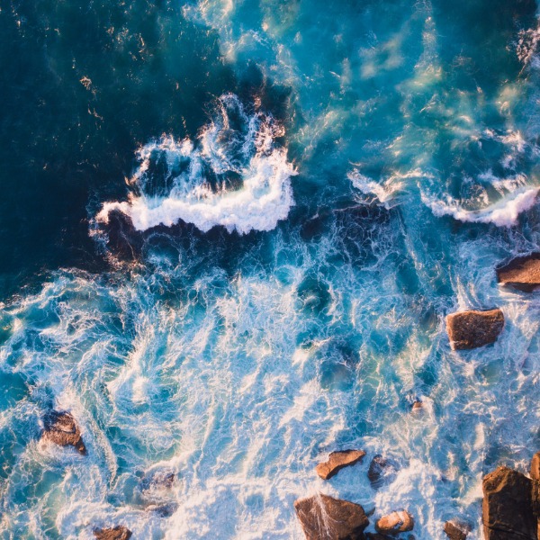
Waves and rocks (ai_yoshi, iStockphoto)

Waves and rocks (ai_yoshi, iStockphoto)
How does this align with my curriculum?
Learn about oceans and ocean currents and how they are being impacted by climate change.
People often say that our planet is a ‘blue’ planet. This is probably because cover 71 percent of the Earth’s surface and contain 97 percent of the planet’s water. Earth’s oceans are home to , such as coral reefs and the abysses. These are among the largest of Earth’s aquatic ecosystems. They are also home to the largest animal on the planet, the .
Did you know?
The blue whale’s heart is the size of a small car!
It may seem like we know a lot about oceans, but we really don’t. We know more about the Moon than we know about our oceans! More than 80% of our oceans have yet to be explored. So let’s dive deep into the characteristics of our ocean planet, from moving water at the surface to the depths of the ocean.
The World Ocean
All water on Earth is part of the The hydrosphere is the total amount of water found on, under, and over the surface of a planet. Oceans are an important part of the hydrosphere.
The oceans on Earth may have different names, but they are really all one ocean. The boundaries only exist on our maps! We will use the term “Ocean” to mean the World Ocean’s body of water. Saline water is water that contains a large amount of dissolved salts.
Misconception Alert
People often use the word “sea” interchangeably with the word “ocean”. The word sea refers to a large body of saline water partly or fully surrounded by land.
Geography
Oceans cover a total area of 360 million square kilometres (km2). 36 countries the size of Canada could fit in it! While the Ocean is geographically one body of water, people refer to five large oceanic areas. From largest to smallest these are:
- Pacific Ocean
- Atlantic Ocean
- Indian Ocean
- Antarctic Ocean
- Arctic Ocean
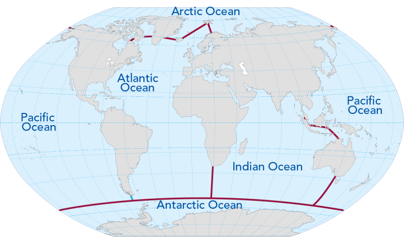
Image - Text Version
Shown is a two-tone map of the the world. Landforms are coloured pale pink and water is coloured pale blue. A dark magenta line separates the ocean regions from each other.
The blue area of water the west of North and South America is labelled as the Pacific Ocean. The water between North and South America and Europe and Africa is labelled as the Atlantic Ocean. The water between Africa and Australia is labelled as the Indian Ocean. The water at the northern part of the map is labelled as the Arctic Ocean. The water at the southern part of the map is labelled as the Antarctic Ocean.
The oceans are not equally distributed over the Earth. Oceans cover about 80 percent of the areas south of the , but only 61 percent of the areas north of the Equator.
Did you know?
The study of all the physics, chemistry, geology, and biology of oceans and seas is called .
Chemistry
Oceans contain seawater. is water that includes a variety of dissolved solids and gases. The total amount of dissolved material is a measure of the water’s . For every kilogram of seawater, there is about 35 grams of dissolved material.
Different parts of the Ocean have different levels of salinity. Differences in salinity can happen because of differences in and precipitation. Higher levels of salinity are found closer to the Equator, where evaporation is greater. Lower levels of salinity are found closer to the North and South poles where there is less evaporation.
Did You Know?
The Dead Sea is actually a salt lake. The water there has 9.6 times the amount of salt in regular ocean water.
Ocean Currents
Water in the Ocean is constantly moving. On a global scale, this water has a great influence on our weather and climate. We use the word to describe the motion of this water. Ocean currents occur for several reasons.
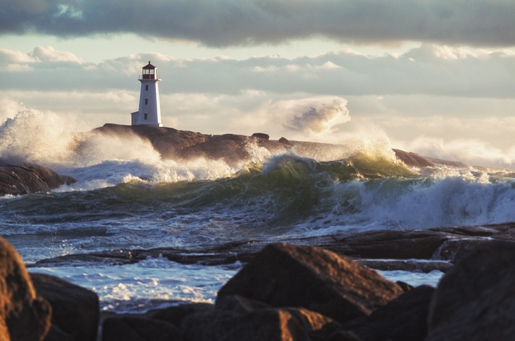
Image - Text Version
Shown is a colour photograph of a lighthouse on a rocky shore. Large waves are seen crashing in. The wind is also blowing water at the peaks of the waves towards the shore.
Surface Ocean Currents
are caused by winds blowing across the surface of the ocean. If the Earth did not rotate, the winds would simply circulate cold, dense air near the poles with warm, less dense air near the Equator. In that case, the ocean surface currents would follow the same path. However, the Earth does rotate which leads to something called the Coriolis Effect. So, instead of following a straight path between the poles and the equator, the circulating air appears to curve to the right in the Northern Hemisphere, in which is North America. And in the Southern Hemisphere, the ocean currents curve to the left. The ocean surface currents in both hemispheres flow in roughly circular patterns called . Watch the video below and pay close attention to 1:47-2:45 min. It explains these big loops or gyres.
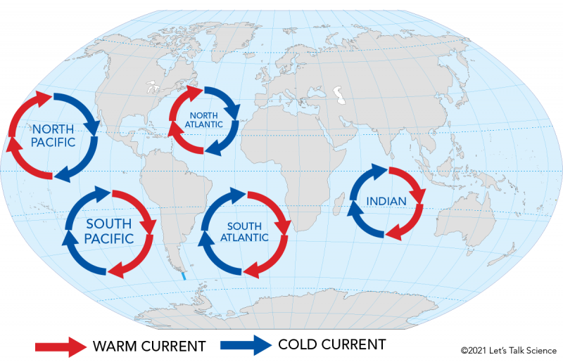
Image - Text Version
Shown is a map of the world indicating the locations of the ocean gyres. Warm currents are indicated with red arrows and cold currents are indicated with blue arrows.
The North Atlantic gyre is found between North America and Europe as well as northern Africa. Arrows indicate that cold water comes down from the north, and bends westward. The water then warms and heads back northwards, now curving to the east.
The North Pacific gyre is found between North America and Asia. Arrows indicate that cold water comes down from the north, and bends westward. The water then warms and heads back northwards, now curving to the east.
The South Pacific gyre is found between South America and Australia. Arrows indicate that cold water comes up from the south, and bends eastward. The water then warms and heads back southwards, now curving to the west.
The South Atlantic gyre is found between South America and Africa. Arrows here follow a similar path to the ones for the South Pacific gyre.
The Indian gyre is found between Africa and southern Asia and Australia. Arrows here follow a similar path to the ones for the South Pacific gyre.
Oceans receive the most of their heat from the Sun in areas near the Equator. This heat is distributed by ocean currents. As surface currents move towards the poles, they carry warm, salty water to the colder polar regions. By the time the water reaches the poles, it has lost this heat. This very cold water becomes denser, causing it to sink. This connects it with deep ocean currents, which we will explore later on.
Ocean Gyres in Action - The Gulf Stream
London, England and Moosonee, Ontario are both located along the same latitude (51oN). Both are also located near large bodies of water. So why is London warmer than Mooseonee? The answer has to do with the warm waters of the .
The Gulf Stream extends from the Gulf of Mexico up the eastern coastline of North America and over to Western Europe. It is caused by the North Atlantic gyre. Early explorers discovered that when they sailed in the Gulf Stream, their ships traveled much faster. It was like being on a highway from Mexico to Spain!
Deep Ocean Currents
are driven by thermohaline circulation. This constant moving up, down and around is also called the Global Ocean Conveyor Belt. Deep ocean currents are caused by changes in the of seawater. The density of seawater can change depending on the temperature and salinity. There is evidence to show that climate change is impacting deep ocean currents.
- Rising sea temperatures are slowing down the conveyor belt. Without the large change in temperature, the current cannot not flow.
- Melting freshwater glaciers and polar ice caps add more freshwater to the ocean. This would result in a drop in the density of the sea water. If the North Atlantic current is not heavy enough to sink as per usual, then the Gulf Stream would not be able to pump warm water.
Already, changes to deep ocean currents are affecting weather patterns on both sides of the Atlantic Ocean.
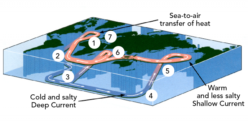
Image - Text Version
Shown is an image of a topographic-like map of the world showing the location of landforms and ocean. Numbers are overlaid identifying the locations on the map of the process described in the text below.
- Deep ocean current circulation begins in the North Atlantic where cold, dense, salty water sinks and flows southward at great depths.
- Next it moves into the South Atlantic.
- Here it mixes with cold and dense water flowing northward from the Weddell Sea, which is a sea in the Antarctic
- This cold, deep water then flows into the Pacific Ocean
- As the deep ocean currents move through the Pacific Ocean, the water is slowly warmed, becoming less dense, and rising to the surface
- The shallower, warmer current moves south across the Pacific Ocean and then westward into the South Atlantic.
- The water then moves north into the North Atlantic where the cycle starts all over again.
Did you know?
The circulation of both the surface and deep currents within the oceans is a main controller of the world’s climate.
Rising Oceans
Not only can global warming lead to changes in deep ocean currents, it also leads to rising ocean levels. Coastal areas risk being flooded and disappearing by rising sea water. As coastal land is no longer above water, people will be forced to move inland. This affects the living space of humans, coastal biodiversity and ecological balance.
Waves and Erosion
Waves have a powerful impact on coastlines. This makes coastal very common worldwide. About 70% of the world’s sandy coast experiences some form of erosion. This process is being made worse by climate change and sea level rise.
The warming of the oceans has made storms more frequent and intense. This means that stronger waves are crashing and breaking up shorelines. For example, in Canada, an that would normally protect shorelines against erosion has been melting with the rising temperatures. In fact, some receding glaciers in the Canadian arctic have exposed land that has been covered by ice for more than 40 000 years!
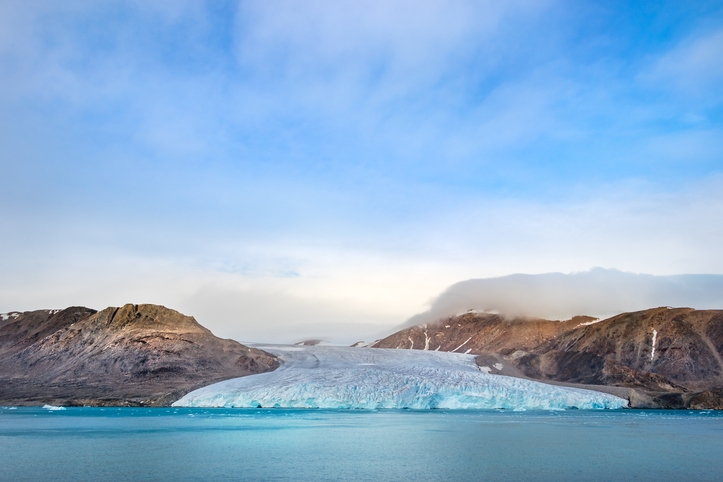
Image - Text Version
Shown is a colour photograph of the foot of a glacier on Devon Island in Nunavut, Canada on a partly cloudy day. In the foreground are clear blue waters of the fjord. In the middle of the photo is the edge of the glacier. It is flat, but has a rough top. It ends at the edge of the water. Smooth barren hills of rock are seen on either side of the glacier.
Did you know?
70% of Canadian coastlines are in the Canadian Arctic.
Both humans and other living things are affected every day by ocean currents. You can read more here about other ocean topics such as Ocean Zones, Waves, Tides and Tsunamis, and ocean warming.
Learn More
How Ocean Currents Work (and How We Are Breaking Them) (2021)
This video (13:46) discusses how ocean currents operate globally and how climate change is slowing them down, a phenomenon which will alter climate patterns across the planet.
Surface Ocean Currents
This page, from the Windows to the Universe website, is about ocean currents.
Tidal Currents
This page, from the US National Oceanic and Atmospheric Administration website, is about tidal currents.
Surface Ocean Currents
This page, from the US National Oceanic and Atmospheric Administration website, is about surface ocean currents.
What is the global ocean conveyor belt?
This page, from the US National Oceanic and Atmospheric Administration website, is about the global conveyor belt.
Thermohaline Circulation: The Global Ocean Conveyor
This page, from the Windows to the Universe website, is about thermohaline circulation.
References
Claiborne, R. (August 25, 2017) Melting Icebergs Alter the Oceans. Retrieved from https://www.nytimes.com/2017/08/25/science/melting-icebergs-alter-the-oceans.html
Kneller, S. (2020, May 24). Coastal Zones, Home to Forty Percent of World's Population. The Explanation. Retrieved from https://medium.com/the-explanation/coastal-zones-home-to-forty-percent-of-world-population-dbbced0fee62
National Geographic Society (2019). The Global Conveyor Belt. National Geographic. Retrieved from https://www.nationalgeographic.org/media/global-conveyor-belt/
Pendelton, S.L., G.H. Miller, N. Lifton, S.J. Lehman, J. Southon, S.E. Crump and R.S. Anderson (2019). Rapidly receding Arctic Canada glaciers revealing landscapes continuously ice-covered for more than 40,000 years. Nature Communications 10 (445). https://doi.org/10.1038/s41467-019-08307-w
Yincan, Y. et al (2017). Coastal Erosion. Marine Geo-Hazards in China (Yincan, Y. et al ed.): 269-296.