Desert Biome
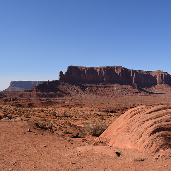
Monument Valley, Arizona (Scott Taylor, used with permission)
Monument Valley, Arizona (Scott Taylor, used with permission)
How does this align with my curriculum?
Learn about the location, plants, animals, human impacts and conservation of the desert biome.
The Terrestrial Biomes
The terrestrial world can be divided into areas called biomes. A biome is a large area of land classified by its plants and animals.
A biome is made up of many ecosystems. An ecosystem is the interaction of living and nonliving things in an environment.
Misconception Alert
An ecosystem is not the same thing as a biome. Biome is the specific geographic area in which ecosystems can be found.
In this backgrounder, major terrestrial biomes of the world are named based on the Whittaker classification scheme.This is not the only classification system because scientists do not all agree on the number and types of biomes.
Distribution of the Earth’s Major Biomes
The map below shows where each of the eight major terrestrial biomes are located in the world. Canada contains four biomes. These are temperate deciduous forest, grassland, boreal forest/taiga, and tundra. A biome has the same characteristics no matter where in the world it is found. This means that the boreal forests of Canada look like the boreal forests of Russia.
The characteristics of each biome are dependent on its climate. Temperature and precipitation are the most important factors determining what living things can be found in a given biome.

Image - Text Version
Shown is a colour world map illustrating the location of terrestrial biomes.
The map shows the world's oceans in blue, and its landmasses in stripes and blobs of eight different colours.
A legend on the right side identifies the biomes associated with each colour. Red is labelled "Tropical Rainforest." Yellow is labelled "Savanna." Gold is labelled "Grassland." Brown is labelled "Chaparral." Pink is labelled "Desert." Dark green is labelled "Temperate Deciduous Forest." Bright green is labelled "Boreal Forest/Taiga." Purple is labelled "Tundra."
Starting at the top, purple indicates Alaska, Canada's arctic, the tip of Greenland, Northern Russia, a strip close to the west coast of South America, and part of Central Asia, are tundra.
Below, most of southern Canada and Russia are bright green for boreal forest/taiga.
A gold blob in the middle of North America, another on the southeast coast of South America, a strip in an arc shape across part of the Middle East and southern Russia, a small part of the southeast coast of Africa, and small parts of the west and south coasts of Australia, indicate grassland.
Dark green appears on the west and east coasts of North America, the west coast of South America, large parts central and southern Europe, the UK, eastern Asia, the southeast corner of Australia, and all of New Zealand. This indicates temperate deciduous forest.
Pink areas are across the western United States, northern Mexico, a narrow strip of South America, most of North Africa and the tip of South Africa, Central Asia and the middle of Australia. These indicate desert.
The brown areas are small and scattered widely. They are along the southwest coast of the United States, the northeast coast and southern tip of Africa, most of Italy, Greece and Turkey, and small parts of southern Australia. These indicate chaparral.
Deserts
Location
When looking at a world map, the majority of deserts are along two lines of latitude. The first line is the Tropic of Cancer. This is located at 30 degrees North latitude. The second line is the Tropic of Capricorn . It is located at 30 degrees South latitude. The air tends to be very dry in these regions of the Earth.

Deserts of the world (Let’s Talk Science using a public domain image from the U.S. Geological Survey).
Image - Text Version
Shown is a world map with areas coloured in shades of orange to indicate three types of arid land.
A legend in the lower left corner is titled "Distribution of Non-Polar Arid Land (after Meigs, 1953)." It indicates that extremely arid land is deep orange, arid land is medium orange, and semiarid is pale orange.
The continents are shown in pale green, and the oceans in pale blue. Several lines of latitude are marked across the map, at 60 degrees north, 30 degrees north, 0 degrees, 30 degrees south, and 50 degrees south.
Staring on the top left of the map, the south western part of North America is streaked with areas of pale orange to the east, and medium orange to the west. Locations in this area are labelled "Great Basin," "Mojave," "Sonoran," and "Chihuahuan."
In South America, the south west coast is marked with a thin strip of deep orange, long blobs of medium orange, and pale areas along the interior. Locations in this area are labelled "Peruvian," "Atacama," and "Patagonian."
A long area of orange crosses the middle of Asia, and another angles down along the west coast of India. This is pale on the outside, and medium inside, with an oval of deep orange in the centre. Locations in this area are labelled "Kara-Kum," "Taklimakan," "Lut," and "Tar."
The Middle East is entirely covered in orange. Most is medium, with a strip of pale across the northwest corner, and an oval of deep in the southeast. The only label in this area is "Arabian."
Much of the northern half of Africa is orange. It goes from pale on the outside to medium, to deep in the centre. The deep orange area is labelled "Sahara" in the west, and "Western" in the east. Below, an area along the east coast is labelled "Somali-Chalbi."
The southwestern tip of Africa is also orange. Deep along the coast, then medium, and pale in the interior.The deep part is labelled "Namib", and the medium "Kalahari."
All of Australia, except most of the coastline, is orange. Pale on the outside, then medium, then deep in the centre. Locations in the deep orange area are labelled "Great Sandy" and "Simpson."
Some deserts are in landlocked regions. These are places not bordered by an ocean. One example of this is the Great Basin Desert in North America. This is the largest desert in the United States. Coastal deserts form near the coasts of continents. Cold air moves from west to east across oceans. This can create cold foggy weather instead of rain on the western coasts of continents. This happens in the Namib Desert in southwestern Africa and the Atacama Desert in South America.
Description
The difference between deserts is their location and type of climate. Deserts receive less than 25 cm of rain each year. Rainfall is what defines a desert, not temperature. Some deserts receive more rain than others.

Aridisols in Monument Valley, USA (Source: tovfla via iStockphoto).
Image - Text Version
Shown is a colour photograph of a landscape of dry, reddish orange soil and distinct rock formations.
In the foreground, the soil is reddish orange, with a few tufts of dry, pale grasses and shrubs. The land beyond is dry and flat. Along the horizon are rock formations with straight sides and flat tops. They look like huge buildings or towers. The sky above is blue streaked with clouds.
Many deserts also experience a lot of wind. We usually think of deserts as being very hot, but some deserts can be very cold. Cold deserts are in the Antarctic as well as Greenland.
Plants & Animals
A desert is often thought of as a windy expanse of sand. But there is more going on in deserts than meets the eye. The plants and animals in deserts have special adaptations. These can help them to live in this sometimes harsh biome.

Golden barrel cacti (Source: Pamla J. Eisenberg from Anaheim, USA [CC BY-SA] via Wikimedia Commons).
Image - Text Version
Shown is a colour photograph of a cluster of green spheres with stripes of yellow spikes.
The spheres are piled together as if they are part of one or two large plants. They are dark green, with pale yellow circles in the top centres. vertical stripes of yellow spikes fan out from the dots, like very thin segments of an orange.

Desert scorpion in Australia (Source: Totajla via iStockphoto).
Image - Text Version
Shown is a colour photograph of reddish orange arachnid with two large claws and long, curved tail.
The animal is on gravel and appears small. It's shell is shiny and varies from dark brown at its claws to pale orange on its back.

Pair of black-tailed prairie dogs (Source: Andyworks via iStockphoto).
Image - Text Version
Shown is a colour photograph of two small, furry animals climbing out of a hole and looking at the camera.
The animals have pale gold fur, and small black claws, eyes and noses. One has its front paws on the front rim of a hole in the soil. The other has one paw and one leg on either side of the rim. Both are looking straight at the camera.
Human Impacts
When humans allow livestock (e.g., cows) to graze on grasslands they turn into deserts. This is called desertification. Population growth and growing cities make this a difficult problem to solve. Other human activities cause damage to desert plants which are slow-growing. Some examples are oil and gas production, urbanization and off-road vehicles such as dune buggies.
Did you know?
The saguaro cactus takes 200 years to grow to full size!
Deserts and Climate Change

Animals at a watering hole in Etosha National Park, Namibia (Source: FernandoQuevedo via iStockphoto).
Image - Text Version
Shown is a colour photograph of several different sorts of animals in and around a body of water in a dry landscape.
Black and white striped zebras, gold springboks with white faces and small dark horns, and brown kudus with long corkscrew horns are gathered around calm water. Some are standing in the water with their heads down, drinking. Others are on the dry, rocky land around.
Conservation

Ditch in the Chihuahuan Desert, New Mexico, USA (Source: Michael Warren via iStockphoto).
Image - Text Version
Shown is a colour photograph of a long, narrow hole, half-filled with water, in a dry landscape.
The hole stretches from the bottom edge of the image, into the distance. There are dusty dirt roads on each side of the ditch. The land around is dry and pale, dotted with a few small green shrubs. There are low, beige mountains on the horizon, and the sky above is blue, streaked with thin clouds.

Desert garden with cacti and succulents (Source: constantgardener via iStockphoto).
Image - Text Version
Shown is a colour photograph of spiky and brightly coloured plants in dry, gravelly soil.
A brown fence runs across the image. Bright pink flowering plants grow against it. On the left is a tall, cylindrical cactus, to the right are two large, round shrubs. One has long, thick, pointed green leaves, and the other has thin. In the foreground are low, rounded plants, some with tiny green leaves, some with thick, grey leaves, and one with tiny pink flowers. All the plants are rooted in pale soil that looks like gravel.
Learn More
Deserts 101 | National Geographic (2019)
This video (3:53 mins), from National Geographic, gives an overview of the four major types of deserts. This includes the animals that live there.
Namibia: Live stream in the Namib Desert (Live Feed: Start Date, 2021)
This live cam from NamibiaCam, lets you watch animals visiting a desert watering hole in real time!
David Attenborough: The Fascinating Life Cycle of Desert Plants | Nature Bites (2022)
In this video (5:41 mins), from Nature Bites, David Attenborough explains some of the fascinating things about desert plants.
References
Arizona-Sonora Desert Museum. (2020). Ground squirrels.
McAuliffe, J. R. (2020). Desert soils. Arizona-Sonora Desert Museum.
National Geographic. (n.d.). Desert threats and endangered species.
University of California Museum of Paleontology. (2019). The desert biome.