Structure of the Earth
Earth’s layers (©2020 Let’s Talk Science)
Learn about the layers of the Earth and discover how people explore the Earth’s crust.
Structure of the Earth
The Earth is made of several layers, These are the core, the mantle and the crust. Each layer has unique characteristics. Let’s look at these layers starting from the inside.
The Core
Located at the centre of the Earth is the core. It has two layers. The inner core and the outer Core.
The core is the Earth's source of internal heat. This is because it contains radioactive materials that release heat as they break down into more stable materials. The inner core has a temperature of up to 4 000℃ and the outer core has a temperature of up to 3 600℃. Between these two layers is a liquid-solid boundary called the Lehmann Discontinuity. This is actually the hottest part of the core. It is as hot as the surface of the Sun!

The layers of the Earth (©2022 Let’s Talk Science).
Image - Text Version
Shown is a colour illustration of Earth's layers, in different colours, from the crust down to the core.
The layers are shown in a narrow strip down the centre of a plain white background.
The top layer is a thin strip of blue. The layer under that is thin, brown and labelled "Ocean Crust." A pointed brown peak that extends from here, up through the blue layer and to the surface is labelled "Continental Crust." The brown layer as a whole is labelled "Crust." Below, a green layer, about twice as thick as the brown is labelled "Asthenosphere." A note in the top right corner reads:"Lithosphere = crust + asthenosphere."
Below is a thick purple layer. A white bracket on the left indicates that this and the asthenosphere is labelled "Upper Mantle, 400 km."
Below this is a very thin blue layer labelled "Transition Zone," in blue letters. Next is a very thick red layer labelled "Lower Mantle, 2885 km." A black bracket on the left indicates that the lower mantle, upper mantle, and asthenosphere are all labelled "Mantle." Another black bracket on the right indicates that the lower mantle is labelled "Mesosphere."
Below this is a thick orange layer labelled "Outer Core, 2270 km." The bottom layer is yellow and labelled "Inner Core, 1216 km." The space between the inner and outer core is labelled "Liquid-solid boundary" in blue letters. A black bracket on the left indicates that both the inner and outer core are labelled "Core."
Did you know?
The inner core is about the size of Pluto.
The Mantle
Above the core is the mantle. Like the core, the mantle also has two layers. These are the lower mantle and the upper mantle. Both layers of the mantle are made up of hot, dense, semi-solid rock.

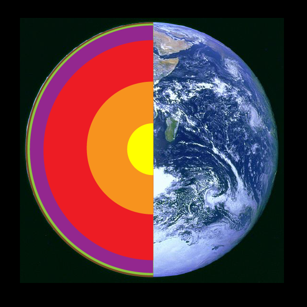
Cross-section of the Earth (Let’s Talk Science using an image by NASA [public domain] via Wikimedia Commons).
Image - Text Version
Shown is a colour illustration of Earth's layers, shown as if the globe has been sliced to show the inside.
The right half of the globe is a photograph of Earth, with oceans, continents, and white swirling clouds. The left half is a half circle with six layers. These are labelled and illustrated using the colours from the diagram above.
The central layer is a yellow half-circle labelled "Inner Core." Outside that is a thick orange arc labelled "Outer Core." Next is a thick red arc labelled "Lower Mantle." Then a thinner purple arc labelled "Upper Mantle." Next is a very thin green arc labelled "Asthenosphere," and a thin, brown, bumpy arc labelled "Crust."
Did you know?
The word asthenosphere comes from the Greek words a and sthenos meaning, “without strength” and sphaira meaning “ball.”
The Crust
Floating on top of the asthenosphere is the crust. The crust is the solid, rigid part of our planet. Unlike the deeper layers, the crust is a cool layer of rock. It has a thickness that varies from 5 to 80 km. Together, the upper part of the asthenosphere and the crust make up the lithosphere.
Did you know?
The word lithosphere comes from the Greek word lithos meaning “rocky” and sphaira meaning “ball.”
The thinnest portions of the crust are found on the ocean floor. It forms what we call the oceanic crust. This part of the crust can be less than 5 km thick.

Where the crust is thin, liquid rock can come to the surface (Source: guenterguni via iStockphoto).
Image - Text Version
Shown is a colour photograph of a puddle of steaming, red-hot lava in a rocky landscape.
Most of the surface of the liquid is black crust. This is criss-crossed with thick cracks that reveal bright orange glowing liquid. A cloud of steam rises from the puddle into the air above.
The land behind the puddle is rough, jagged layers of brown rock. In the distance are two small mountain peaks and blueish grey sky.
Human Explorations of the Earth’s Crust
Humans know more about the edge of the Universe than what lies beneath the Earth’s crust. Much of what we know comes from seismology. Seismology is the study of how waves of energy produced by earthquakes travel through the Earth. By observing how these waves bend or refract as they travel from place to place, scientists can understand how dense the parts of the core materials are.
Did you know?
In 1936, a pioneering woman seismologist from Denmark used evidence from earthquakes to prove that the Earth had a solid core.

An illustration from the novel Journey to the Center of the Earth by Jules Verne by Édouard Riou (1864) (Source: Édouard Riou [Public domain] via Wikimedia Commons).
Image - Text Version
Shown is a black and white illustration of dinosaurs in and around water, surrounded by rock with mushrooms growing on it.
The illustration is oval-shaped and framed with a border of jagged rock. It is as if the artist has cut a hole through the rock to find the scene. The image is made with fine black lines and crosshatching to create shadows and light.
Bird-like dinosaurs fly in the overcast sky. Long-necked dinosaurs swim in the water below. An alligator-like creature in the foreground has pointed white teeth. Five large toadstools are growing on a rocky outcropping on the left of the image.
Project Mohole
The challenge of going deep into the Earth did inspire some explorers. For example, during the early 1960s, there was a project to dig down through the Earth’s crust. The project was called Project Mohole. It was named after the boundary between the crust and mantle, called the Mohorovicic Discontinuity (or Moho for short). The layer was named after the person who discovered it, geologist Andrija Mohorovicic.

Scale model of the Mohole drilling platform (Source: Mohole Project [public domain] via Wikimedia Commons).
Image - Text Version
Shown is a black and white photograph of a model of a platform with six pillars and a metal tower.
The platform is rectangular, and built on pillars attached to two large tubes, that look like airplane floats. On the top surface is a tiny helicopter on a landing pad, two cranes, and several small buildings. In the centre is a tall, pointed tower, made from metal struts. The whole model is mounted on a polished wooden plaque.
Kola Superdeep Borehole
Geologists on land were going much deeper. In 1970, Soviet geologists started drilling into the Kola Peninsula, near Finland. They hoped to drill down further into the Earth than anyone had drilled before.

Commemorative stamp of the Kola Superdeep Borehole, 1987, USSR (Union of Soviet Socialist Republics) (Source: Scanned and processed by Mariluna [Public domain] via Wikimedia Commons).
Image - Text Version
Shown is a postage stamp with Cyrillic text and an illustration of a borehole overlaid on a landscape.
A black line drawing of the borehole runs from the top to bottom, along the right side. It has an inner tube, labelled with arrows pointing down. The space on each side of the hole is labelled with arrows pointing up. These turn out to each side once they reach the surface.
In the background is a green and grey illustration of a tall tower with long windows, surrounded by low buildings. The landscape around is barren, and the northern lights shine in the sky above.
More recently, 1n 2022, Adnoc, the Abu Dhabi National Oil Company, set a record for the longest oil and gas well. The well was drilled at its Upper Zakum oilfield. The well is 15 240 metres long. This well beats the previous record set in 2017 for a well drilled off the coast of Russia that was 15 000 metres long.
Another energy company is also determined to dig deep, but not for oil and gas. A company formed in 2020, named Quaise Energy, wants to drill down to capture Earth’s geothermal energy. They plan to use high-energy waves to melt rock. This could allow them to reach up to 20 km below the Earth’s surface! They plan to have their first drill operational by 2024.
So, why should we care about what goes on inside the Earth? Understanding Earth’s interior helps scientists to more accurately predict geological events such as earthquakes and tsunamis. Knowing in advance when these events will happen can help save thousands of lives across the globe.
Learn More
The First Deep Ocean Drilling (2011)
This is a historical film (18:38 min.) from the 1960s showing how they drilled for Project Mohole.
Unlocking the true power of clean geothermal energy
Learn more about how Quaise Energy plans to drill deeper than ever before.
References
Rogtec Russian Oil & Gas Technologies (2017, November 16). Sakhalin-1: Drills worlds longest horizontal well.
Umino, S. (2015). PROJECT M2M-MoHole to Mantle – MANTLE QUEST THOROUGH ULTRADEEP OCEAN DRILLING BY THE DEEP SEA SCIENTIFIC DRILLING VESSEL CHIKYU. Journal of Japan Society of Civil Engineers Ser A2 (Applied Mechanics) 71(2): 3-10.
Venturini, I. P. (2017, November 17). The longest well has been drilled in Sakhalin-1 project. Industrial Valve News.
Voosen, P. (Mar 31, 2022). The Planet Inside: Scientists are probing the secrets of the inner core - and learning how it might have saved life on Earth. Science.