Weather: Temperature
Warm and cool Earth (Let’s Talk Science using image by filo, iStockphoto)

Warm and cool Earth (Let’s Talk Science using image by filo, iStockphoto)
How does this align with my curriculum?
Temperature affects the way we live, the clothes we wear and activities we do. But how does temperature vary across the globe?
Temperature
Why is there sometimes snow on the top of a mountain but not at the bottom? And why is the Arctic always cold while the Tropics are always hot? Let’s find out!
Elevation and Altitude
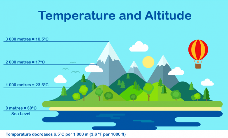
The vertical distance between sea level and where you are is your elevation. The greater your elevation, the less air there is above you. This means the air pressure is lower. The less pressure there is on the air, the more it expands. And the gases that make up the air get cooler as they expand. So, the air temperature drops about 6.5 °C for each kilometre you climb.
Did you know?
Elevation is how high land is above sea level. Altitude is how high an object is above sea level.
You can even feel this without climbing at all! Try using a can of compressed air, or let the air out of a tire. The air inside is under pressure. But when it comes out, it suddenly expands, so it is colder than the air around you.
Image - Text Version
Shown is a colour illustration with temperature and altitude from the ocean to a mountain peak. The title, “Temperature and Altitude,” is in bold letters across the top. At the bottom of the image are blue streaks with a beige stripe of beach above. This is labelled, “0 metres = 30℃, Sea Level.” Above the beach is an area of green grass, trees, and rolling hills. A point about halfway up one of the taller hills is labelled, “1000 metres = 23.5℃.” Above the hills are pointy grey mountains with snow capped peaks. There are fluffy clouds, birds, and a hot air balloon in the sky about halfway up the mountainsides. A point here is labelled, “2000 metres = 17℃.” The snow-covered mountain peak is labelled, “3000 metres = 10.5℃.”
Did you know?
The cruising altitude of commercial airliners is about 11 km above Earth. At that altitude, the air pressure is about 25% of what it is on the ground. The temperature outside the plane is about -55 °C!
Latitude
Places on Earth can have very different temperature patterns. This is because of the Sun. The more sunlight that shines on a place, the hotter it will be.
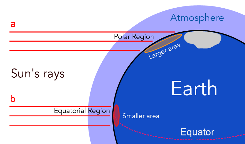
The Earth is a sphere. The places where sunlight hits the Earth at a right angle get a lot of sun in a small area. This area is close to the equator. It’s called the equatorial region. The places where sunlight hits the Earth at a shallow angle get the same amount of sunlight, but it’s spread over a much larger area. Areas like this are close to the north pole or the south pole. They’re called the polar regions.
In the picture below, you can see that the same amount of sunlight covers a large area (a) at a polar region and a small area of (b) at the equatorial region. Because area b is smaller than area a, the sunlight is more concentrated there. This means there are warmer temperatures at b than at a.
Image - Text Version
Shown is a colour diagram of sunlight shining on Earth near the Equator and the North Pole. A dark blue, quarter circle on the lower right of the image is labelled “Earth.” A pale purple stripe above its curved surface is labelled “Atmosphere.” A curved red, dotted line across the middle of the circle is labelled “Equator.” A pale grey blob at the top indicates an ice-covered pole. Red horizontal lines extend from the left side of the image, toward Earth. These are labelled “Sun’s rays.” The top three red lines are labelled “a” and “Polar region.” They meet Earth’s surface near the pole. The points where the lines intersect with the surface are spread far apart. This is marked with a long orange oval labelled “Larger area.” The bottom three red lines are labelled “b” and “Equatorial Region.” They meet Earth’s surface at the red dotted line. The points where the lines intersect with the surface are close together. This is marked with a small red oval labelled “Smaller area.”
Seasonal Temperatures
The Earth spins on its axis. If that axis stood straight up, Earth's equator would always face the Sun as the planet orbited around it. But this would mean that the Northern Hemisphere would stay cold all year round. We know that that doesn’t happen. In North America, winter is colder and summer is warmer. Spring and autumn are in between.
The Earth has seasons because it is tilted at an angle of 23.5°. As the Earth moves around the Sun, the planet is tilted either towards, or away from the Sun. Let’s see how this works in different seasons.
Did You Know?
The northern end of the Earth’s axis always points to basically the same place in space. This explains why the North Star can always be used to find north in the Northern Hemisphere.
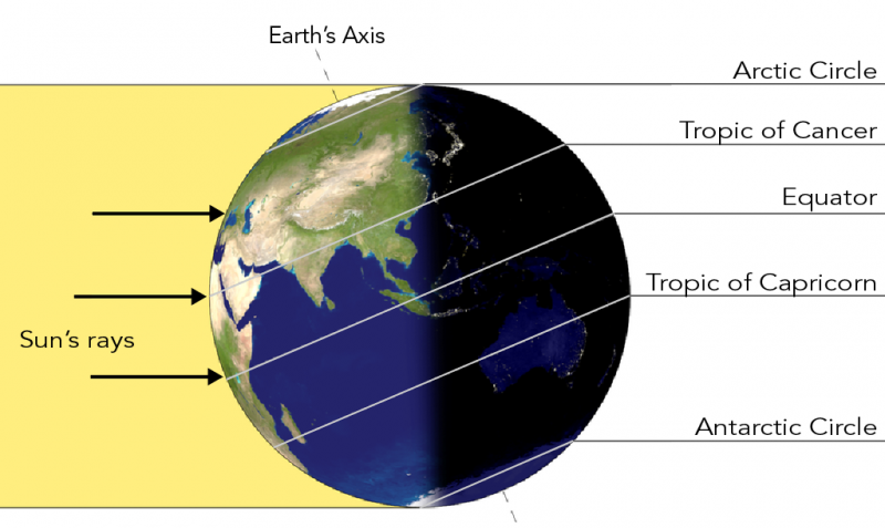
In the Northern Hemisphere summer is from June to September. This is when the area north of the Equator is tilted towards the Sun. In North America, calendars are set so that the Sun is directly overhead at its furthest north position on June 21 or 22. This is called the Summer Solstice.
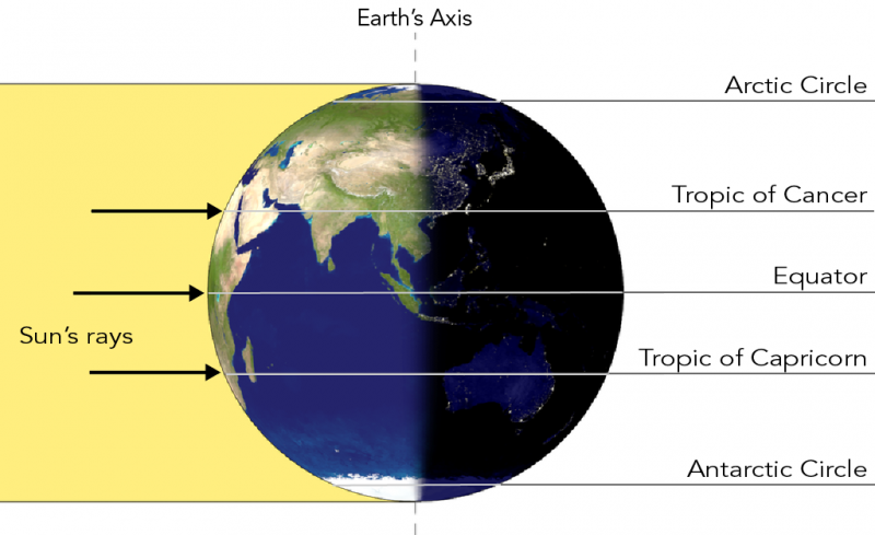
The picture below shows the Earth at the Summer Solstice. You can see which part of the Earth is lit and which part is in shadow. More of the Northern Hemisphere is in the light half than in the dark half. This is why days are longer in the summer. In fact, above the Arctic Circle, there are 24 hours of daylight at the Summer Solstice!
Image - Text Version
Shown is a colour diagram of Earth’s Northern Hemisphere tilted towards the Sun. Earth is shown as a circle with blue water and green and beige land. A wide yellow stripe with arrows pointing right, goes from the left edge of the image to Earth’s surface. This is labelled “Sun’s rays.” The left half of Earth is brightly lit. The right half is in the dark. Earth’s axis is shown as a dotted line pointing up from the North Pole and down from the south pole. This indicates the line goes through Earth’s centre from top to bottom. The axis is tilted to the left, so the North Pole is part of the brightly lit half, and the South Pole is in the dark. There are several white lines across Earth, perpendicular to its axis. The one near the top of the globe is labelled “Arctic Circle.” The one near the bottom is labelled “Antarctic Circle.” The one in the middle is labelled “Equator.” The line between the Arctic Circle and the equator is labelled “Tropic of Cancer.” The line between the equator and the Antarctic Circle is labelled “Tropic of Capricorn.”
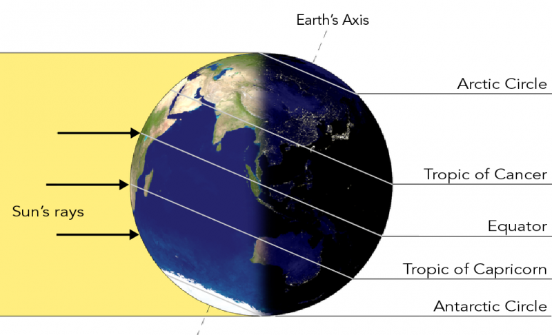
The opposite happens in winter in North America. During this part of the Earth’s orbit, the Northern Hemisphere is tilted away from the Sun. The picture below shows the Earth at the Winter Solstice on December 21 or 22. More of the northern hemisphere is in the dark half than the light half. This is why the days are shorter in winter, and why the nights are longer. Winter Solstice is the longest night of the year. As you may have guessed, above the Arctic Circle, there are 24 hours of darkness at the Winter Solstice!
Image - Text Version
Shown is a colour diagram of Earth’s Southern Hemisphere tilted toward the Sun. Earth is shown as a circle with blue water and green and beige land. A wide yellow stripe with arrows pointing right, goes from the left edge of the image to Earth’s surface. This is labelled “Sun’s rays.” The left half of Earth is brightly lit. The right half is in the dark. Earth’s axis is shown as a dotted line pointing up from the North Pole and down from the south pole. This indicates the line goes through Earth’s centre from top to bottom. The axis is tilted to the right, so the North Pole is part of the dark half, and the South Pole is brightly lit. There are several white lines across Earth, perpendicular to its axis. The one near the top of the globe is labelled “Arctic Circle.” The one near the bottom is labelled “Antarctic Circle.” The one in the middle is labelled “Equator.” The line between the Arctic Circle and the equator is labelled “Tropic of Cancer.” The line between the equator and the Antarctic Circle is labelled “Tropic of Capricorn.”
The picture below shows the Earth at the Autumnal Equinox and at the Spring Equinox, which is also called the Vernal Equinox. The Northern Hemisphere is not tilted towards, or away from the sun. These dates are when day and night are exactly the same length.
Image - Text Version
Shown is a colour diagram of Earth with the North Pole pointing up, and the South Pole pointing down. Earth is shown as a circle with blue water and green and beige land. A wide yellow stripe with arrows pointing right, goes from the left edge of the image to Earth’s surface. This is labelled “Sun’s rays.” The left half of Earth is brightly lit. The right half is in the dark. Earth’s axis is shown as a dotted line pointing up from the North Pole and down from the south pole. This indicates the line goes through Earth’s centre from top to bottom. The axis is perfectly vertical, so each pole is half bright and half dark. There are several white lines across Earth, perpendicular to its axis. The one near the top of the globe is labelled “Arctic Circle.” The one near the bottom is labelled “Antarctic Circle.” The one in the middle is labelled “Equator.” The line between the Arctic Circle and the equator is labelled “Tropic of Cancer.” The line between the equator and the Antarctic Circle is labelled “Tropic of Capricorn.”
Equinoxes and solstices are points in time. They are moments when the Earth’s angle is perfectly aligned with the Sun’s rays. But people sometimes use these names for the whole day on which these times fall.
Perceived temperature vs real temperature
The temperature outside is not the only thing that makes you feel cold or warm. This is why weather forecasts sometimes give you a second temperature. This is based on how people feel. You might feel colder on a windy day. This perceived temperature is called wind chill. You might feel hotter on a humid day. This perceived temperature is often called humidex.
Learn More
How can I tell which way is north at night?
This hands-on activity helps you find some common constellations.
Why do we have seasons?
This backgrounder explains why seasons change as well as how seasons differ in the Northern and Southern hemispheres.
Seasons and the Sun (2015)
This video (3:56 min.) by Crash Course Kids illustrates how the sun affects seasons, temperatures and the length of days across the globe.
Why Does Altitude Affect Temperature? |James May's Q&A (2013)
This video (3:19 min.) by BBC Earth Lab explains why the temperature drops the higher you go, and what happens if you go too far!
What's the difference between temperature and wind chill? (2019)
This video (1:26 min.) by CityNews Toronto explains the difference between temperature and wind chill, and the dangers if you're not dressed properly.
What the winter solstice means in the Cree tradition | Ask an Elder (2017)
This video (1:03 min.) by CBC News explains the significance of the winter solstice in Cree culture and astronomy.
References
Canadian Centre for Occupational Health and Safety. (2019). Humidex Rating and Work : OSH Answers.
Deziel, C. (2018), How Does Latitude Affect Climate? Sciencing.com.
Eldridge, A. (n. d.) What's the Difference Between a Solstice and an Equinox? Britannica.com.
Government of Canada. (2019). Guide to public weather forecasts: weather elements.
Kozlowski, R. (2020). How to Calculate a Wind Chill Factor. Sciencing.com.
NASA Space Place. (2020). What Causes the Seasons?
UCAR Center for Science Education. (2013). Change in the Atmosphere with Altitude.
