Ice on Earth - The Cryosphere
Sea ice (Michal Balada, iStockphoto)

Sea ice (Michal Balada, iStockphoto)
How does this align with my curriculum?
Learn about the cryosphere and how it is being impacted by climate change.
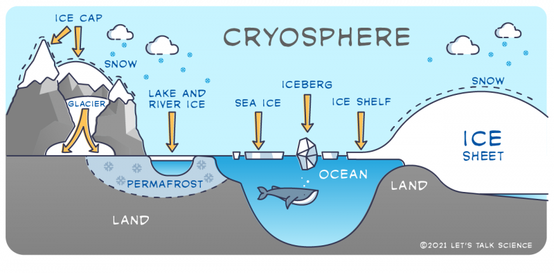
Not all of the water on Earth exists as a liquid. A large part of the Earth’s water exists in its solid form. The term that describes all of the solid water on Earth is the cryosphere. The cryosphere includes lake and river ice, sea ice, snow cover, glaciers, ice caps, ice sheets and water frozen in soil known as permafrost.
Image - Text Version
Shown is an infographic of the parts of the cryosphere.
Land is shown in gray, water in blue and snow and ice in white. On the left side are mountains. On their peaks are are ice caps. In the valley between the mountain peaks is a glacier. Down under the surface of some parts of the land is an area identified as permafrost. There is ice covering a small lake. In the middle of the image is an ocean with a whale. At the surface of the ocean is a flat piece of ice identified as sea ice, and a jagged piece of ice identified as an iceberg. To the left of the ocean is a large ice sheet which sits on land. Part of the ice sheet extends onto the surface of the ocean. This is identified as an ice shelf. Snow is also falling and accumulating on the ice cap and ice sheet.
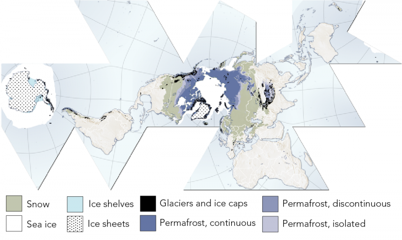
Most of the cryosphere is located in polar regions. The further north you go, the more ice there is. All parts of Canada are in the cryosphere in some way.
Image - Text Version
Shown is a Fuller Project map of the Earth showing the locations of snow, sea ice, ice shelves, ice sheets, glaciers, ice caps and permafrost.
Antarctica is covered by ice sheets and is surrounded by ice shelves and sea ice with a few glaciers. Some glaciers are also identified along the western coast of South America. The northern Arctic is mainly sea ice and Greeland is covered by an ice sheet. As you go further south in North America, Europe and Asia, you go from continuously frozen permafrost to discontinuous permafrost to isolated permafrost in northern parts of Canada. Southern Canada and into the United States is marked as having snow. This is similar in Europe and Asia. Around major mountain ranges, such as the Rocky Mountains in western Canada, glaciers and ice caps are found.
Let’s look next at all of the different parts of the cryosphere.
Bodies of Ice
Glaciers
Glaciers are bodies of ice that are often hundreds or thousands of years old. A glacier forms from the build up of snow. They are the largest source of freshwater and the second largest source of total water in the world. Oceans are the largest.
Image - Text Version
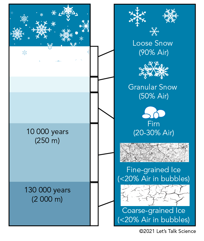
Shown is an infographic identifying the layers of a glacier and the snow and ice that form it.
The topmost layer of a glacier is loose snow. This is a fairly thick layer of the glacier. Loose snow is about 90% air. Below this is granular snow. This is snow that is more closely packed together. This is a thinner layer of the glacier. Granular snow is about 50% air.
Below this is a layer of firn. Firn is a type of granular ice pellet. The firn layer is similar in thickness to the loose snow layer. Firn is about 20-30% air.
Below this, at around 230 metres below the surface, is a layer of fine-grained ice. This ice is around 10 000 years old and is a fairly thick layer. Many tiny bubbles and cracks are in this layer. This ice layer is less than 20% air.
The lowest layer, at around 2 000 metres, is a layer of coarse-grained ice. This ice is around 130 000 years old. There are fewer bubbles and cracks in this layer. This layer has less than 20% air.
On Earth, 99 percent of glacial ice is contained within vast ice sheets in the polar regions called continental glaciers. But glaciers can also be found in mountain ranges on every continent. These are called alpine glaciers.
Ice Sheets
Ice sheets are huge pieces of glacial ice which have an area of at least 50 000 km2. During the last ice age, also known as a glacial period, an ice sheet called the Laurentide ice sheet covered much of North America. Today, the only ice sheets on Earth are in Antarctica and Greenland. In the video below, you can see the evolution of the ice sheet that once covered a much bigger part of the continents. It also shows a vision for the future of the cryosphere if we stop emitting carbon dioxide into the atmosphere by 2100.
Image - Text Version
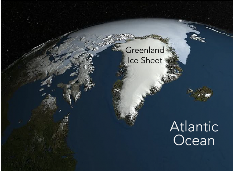
Shown is a colour satellite image of Greenland, the northern Arctic and the Atlantic Ocean. Greenland is a large kite-shaped landform covered by a white ice sheet located in the centre-right part of the image. Sea ice can be seen surrounding the northern part of Greenland, and open ocean to the south of Greenland. This ocean is the Atlantic Ocean.
Ice Caps, Fields and Shelves
Sheets of ice smaller than 50,000 km2 are called ice caps and ice fields.Ice caps can take any shape, but are typically found on mountain tops. Ice fields have a shape determined by where they are.
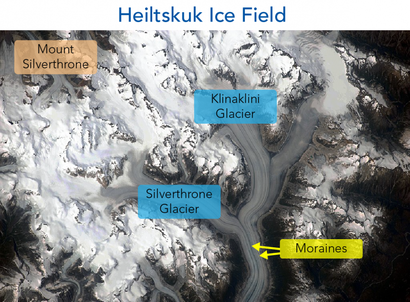
The photograph below shows the Heiltskuk ice field in British Columbia. It is an ice field that is mostly covered in snow. There are also two valley glaciers in this ice field. They are small alpine glaciers found in valleys that extend out from the ice field. In the image you can see the Silverthrone Glacier and the Klinaklini Glacier. The long, dark lines in the middle of the glaciers are moraines. These are accumulations of rock and soil transported by the moving glaciers.
Image - Text Version
Shown is a black and white satellite image of the Heiltskuk Ice field in British Columbia.
The upper left region is identified as Mount Silverthrone. It has multiple sharp peaks covered mostly by snow. Looking like grayish rivers coming from the mountain are two glaciers. The glacier coming down from the top left is identified as the Klinaklini Glacier. Joining this glacier from the centre left is the Silverthrone Glacier. In the glaciers are dark lines that run parallel to the direction of the glacier. These are identified as moraines.
Glacier Movement
Due to the pressureof the layers of ice above, the lower layers of ice in a glacier change shape. This allows them to move slowly, like a thick fluid. A glacier can move across ground or even up a slope if new snow is deposited at its base. Melting ice underneath a glacier can also cause it to flow across the ground.
Glaciers that move faster than other parts of an ice sheet are called ice streams. These ice streams can go even faster when there is water flowing underneath them. In Antarctica, most of the ice and sediments that end up in the ocean are transported there by ice streams.
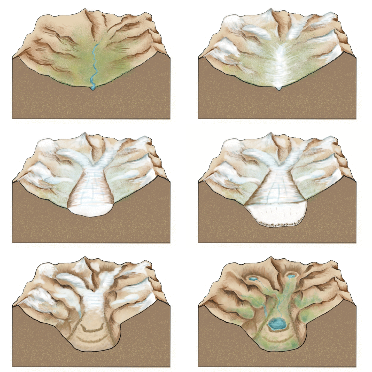
As a glacier moves, it tends to collect rocks, boulders and gravel. This material is known as glacial till. As a glacier passes over land, it wears away or erodes the bedrock and carries away the debris. The movement of glaciers and the erosion they cause can really change a landscape!
For example, before a glacier moves across it, a valley tends to have a “V” shape caused by erosion from water. After a glacier moves through it, a valley becomes deeper and wider, which gives it a “U” shape. When glaciers retreat by melting, glacial till is left behind.
(Source: Cecilia Bernal [CC BY-SA 4.0] via Wikimedia Commons).
Glaciers that end in the ocean are called tidewater glaciers. In Canada, tidewater glaciers can be found on Baffin Island and Ellesmere Island. As a glacier reaches the ocean, the upper layers become brittle and often form deep cracks called crevasses. When crevasses go all the way through the ice, pieces can break off. This is known as calving. There are different names for the different types of ice pieces. The best-known are icebergs. These are pieces of ice that measure more than 15 metres long. Icebergs can also break away from ice shelves which are areas of floating ice, often located at the edge of an ice sheet.
As most of the pieces of ice break off above sea level, there are often spectacular splashes when the ice falls into the water. Some people travel the world to see such things!
Icebergs
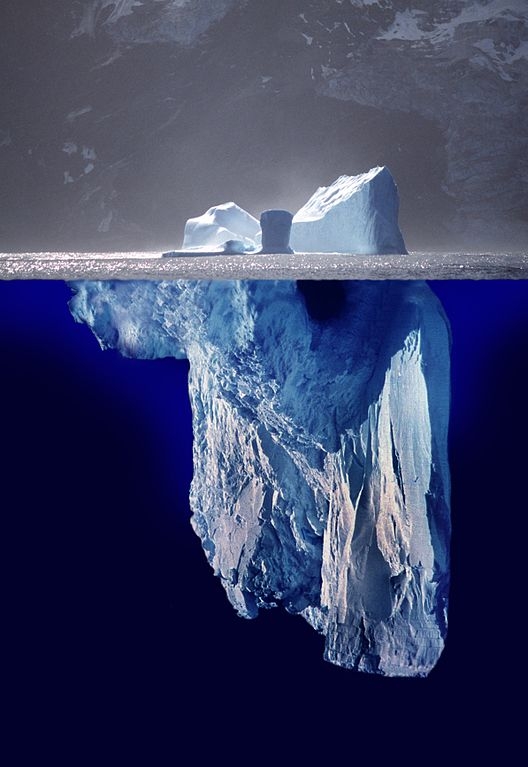
Image - Text Version
Shown is a colour photomontage of an iceberg in the ocean. Above the surface, a small amount of jagged bluish ice can be seen. The bulk of the iceberg, about 90%, is visible below the surface of the water. The ice is shades of blues and violets and the ocean water is deep indigo.
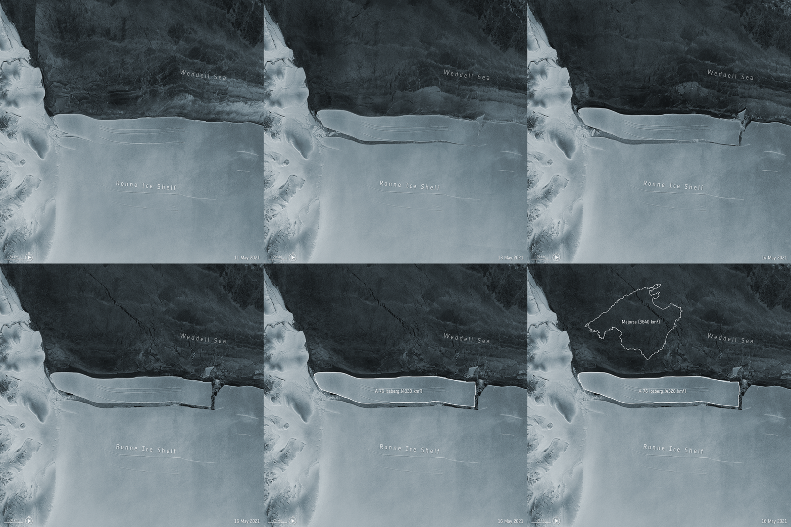
Icebergs generally range from one to 75 metres in height above sea level. They tend to weigh between 100 000 to 200 000 metric tons. The biggest recorded iceberg calved off the Ronne Ice Shelf in Antarctica in May 2021. The piece was about the size of Prince Edward Island!
Iceberg A-76 breaking off Antarctica (Source: European Space Agency via Wikimedia Commons).
Image - Text Version
Shown is an animated gif of the iceberg A-76 calving off of the Ronne Ice Shelf in Antarctica and ending up in the Weddell Sea. The gif is made from a series of black and white satellite photos.
Located in the upper half of the image is the Weddell Sea. It is a dark gray colour. Some wave patterns are visible. Located in the lower half of the image is the Ronne Ice Shelf. It is a pale gray colour and appears to be very flat. At the beginning of the animation, there is a thin crevasse in the ice shelf about a quarter of the way down from the upper edge on the left side. The crevasse quickly widens and then the ice begins on the left side to move away from the main ice sheft. This ends up breaking the piece off. The new iceberg is about three quarters of the width of the ice sheet. At the end of the animation, the new iceberg is free floating. Text identifies the iceberg as being called A-76 with an area of 4 320 square kilometres.
Sea Ice
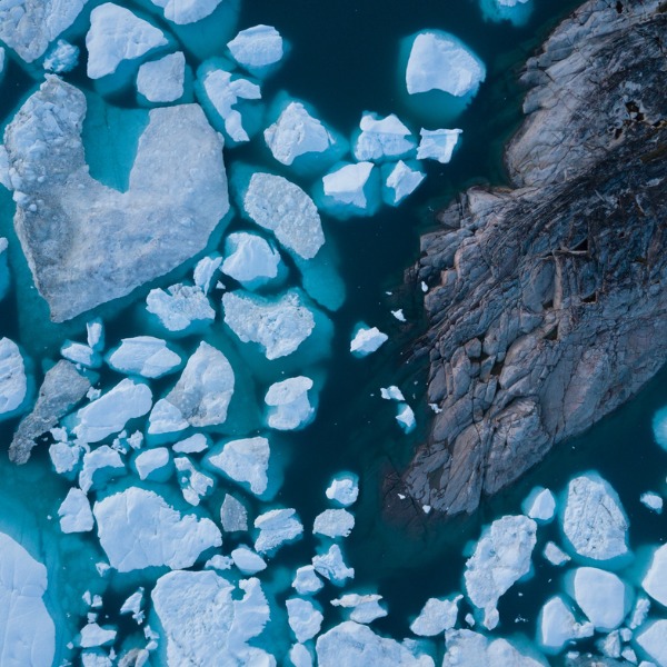
Unlike icebergs, which are made of freshwater ice, sea ice is made of frozen seawater. Sea ice covers about 7% of the ocean but represents less than a hundredth of the planet’s ice in volume. This is because it is much thinner than the ice of glaciers and ice caps.
Sea ice can be classified according to whether or not it is connected to a shoreline or floating freely. If it is attached to land, it is called landfast ice or fast ice , which is short for ‘fastened’ ice. If it can drift freely, it is called drift ice. Individual chunks of drift ice that are 20 metres or larger are called ice floes.
The Cryosphere and Climate Change
The cryosphere, like oceans, plays an important role in global climate systems. How big a role it plays depends on how long it stays frozen. Lake and river ice and much of the snow cover only lasts for one season before it melts. Some sea ice may stay frozen for several years, while ice in glaciers and ice sheets may stay frozen for 10 to 100 000 years or more. Some ice, deep in the eastern part of the Antarctic is believed to be close to one million years old!
The seasonal freezing and thawing of ice has a huge effect on regulating ocean temperatures. Ocean temperature variations are an important factor creating ocean currents. Ocean currents influence atmospheric weather and climate.
Did you know?
One metre of ice cover reduces the heat exchange between Earth and the atmosphere by a hundred.
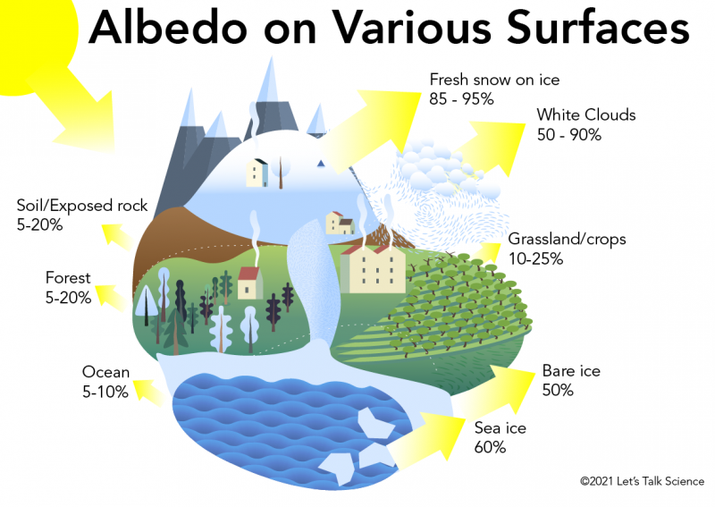
Another way that ice impacts climate is albedo. This is a scientific term used to describe how a surface reflects energy, such as heat and light. Ice has a large albedo. This means that it reflects a lot of the energy from the Sun. Oceans have a small albedo. This means that they absorb, rather than reflect, radiation from the Sun. This is a problem because as more ice melts, more energy is absorbed by the ocean. And the more the oceans warm up, the more the ice melts. This is called the ice-albedo feedback loop. It is a positive feedback loop because the result of ice melting makes even more ice melt.
Image - Text Version
Shown is a colour infographic of various natural surfaces and their albedo values.
In the centre of the image is a scene with mountain peaks, a snowy hillside, a forest with a house, exposed rock, an orchard, a glacier coming down to the ocean, and an ocean with icebergs. Clouds hover just above the scene, and some snow is falling. The following are the albedo values, from highest to lowest:
Fresh snow on ice: 85-95%
White clouds: 50-90%
Sea ice: 60%
Bare ice: 50%
Grassland/crops: 10-25%
Soil/exposed rock: 5-20%
Forest: 5-20%
Ocean: 5-10%
Another important role of ice is as a freezer for storing information about the Earth’s past. Paleoclimatology is the science that studies the climate of the planet’s past. Paleoclimatologists study materials trapped in ice or soil to understand the Earth events that have happened over time. For example, scientists used data from paleoclimatology to determine that huge volcanoes erupted and caused the Earth’s ice ages. Scientists can even study the gases produced thousands of years ago by analyzing what is found in bubbles trapped in the ice.
To gather their samples, paleoclimatologists gather core samples. You can learn more about this process in the video below.
Air bubbles trapped in ice contain carbon dioxide (CO2). This makes ice a carbon sink. This means that the ice traps and keeps CO2 from being released into the atmosphere. Bubbles can also contain methane. Methane is a greenhouse gas that absorbs 25 times more heat than CO2. This makes it an important contributor to climate change.
As polar ice and permafrost melt, bubbles release their greenhouse gases into the atmosphere. This is another positive feedback loop. As more greenhouse gases warm up the atmosphere, more ice melts, releasing more greenhouse gases. In fact, a scientist has estimated that the gases released from ice melting is equal to what humans have released in the same amount of time, doubling the effect!
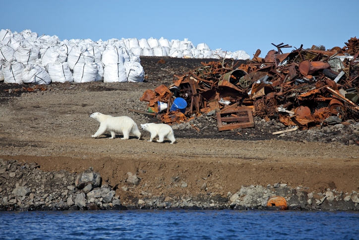
The melting ice dramatically changes the ecosystems of polar animals and migrating animals who feed in polar regions. Many of those animals, like polar bears, are finding it harder and harder to find food.
Image - Text Version
Shown is a colour photograph of an adult and young polar bear walking near a dump. The polar bears are walking from right to left along a brownish, gravel area near an open body of water. To the right is a large pile of rusty metal objects. To the left are numerous sealed white waste bags.
Not only can a loss of ice change animal behavior, it can also mean that northern communities who hunt these animals may lose an important food source. These communities may need to adapt traditional practices, such as hunting, to the changing landscapes. For example, the rapid melting of glaciers and ice sheets increases the hazards for those travelling across icy lands.
Another effect of ice melting is the increased sea level. This result of climate change is especially felt by coastal communities who are losing their land to sea. For some people living on islands, it can mean losing their homes as islands disappear underwater. The term for people who lost their homes to climate change are now known as climate refugees or environmental migrants.
No matter where you live on Earth, from the poles to the Equator, you cannot escape the influence of the cryosphere.
Learn More
Animation: How A Glacier Melts
This YouTube video (1:11) from NASA shows the process by which a glacier melts.
Antarctic Glaciers
This website offers lots of information on the science of ice or glaciology.
Ice Sheet
This page, from National Geographic Education, is about ice sheets. It includes some interesting photographs.
Icebergs
On this website you can see maps of current active icebergs as well as learn more about iceberg spotting technology such as RADARSAT and watch videos of icebergs seen off of Newfoundland and Labrador.
All About Glaciers
This website, from the National Snow and Ice Data Center, has a lot of information about glaciers – including how they are formed, how they move, and what they are made of.
Global Ice Viewer
This website, powered by NASA as part of their indicators of climate change series, shows the global concentrations of ice and their reduction.
Greenland's Moving Ice Sheet
This video file, part of the Wikimedia Commons collection, provides a narrated tour through Greenland's moving ice sheet from NASA scientist Eric Rignot.
References
National Snow & Ice Data Center (n.d.). Quick Facts on Ice Sheets.
Roger Williams University (n.d.). Ice. Introduction to Oceanography. Retrieved from https://rwu.pressbooks.pub/webboceanography/chapter/chapter-14-ice/
